If you are grading land, building, or clearing trees on a development site in Strongsville, the city may ask for a Tree Preservation Plan before it issues your permits.
That sounds complicated. It is not, once you see what it is for.
What it is
A Tree Preservation Plan is a map and written plan that shows:
- The shape of the lot
- Where buildings, utilities, and grading will go
- Every tree 6 inches or wider (measured 4½ feet above the ground — called dbh)
- Which trees stay, move, or get removed
- How trees that stay will be protected during construction
Think of it as a tree inventory tied to a site plan.
Under Strongsville Codified Ordinance Chapter 1025, no building permit, grading plan, or erosion permit can be issued until tree rules are met. For many sites, that means an approved Tree Preservation Plan reviewed by the City Forester and, when required, the Planning Commission.
Why the city cares
The law is not just about saving pretty trees. Strongsville lists real reasons:
- Slow stormwater runoff
- Cut erosion and sediment
- Shade and screen neighboring properties
- Filter air and reduce noise
- Protect wildlife habitat and property values
So the plan is part drainage, part ecology, part neighborhood character.
What has to be on the plan
Chapter 1025.06 says the plan generally needs:
- Lot dimensions and proposed structures
- Location and species of protected trees (6"+ dbh)
- How remaining trees will be fenced or barred off during work
- Setbacks and easements
- Proposed grade changes
- Any tree replacement program
- Trees flagged or painted on site before inspection
- Often a sealed topographic survey — and sometimes an aerial photo or formal tree survey at 1" = 200' scale
If no qualifying trees exist, you can file a no tree verification after the Forester checks the site.
Money and timing
- Permit fee: $100 (single-family lot) or $250 (other lots)
- Deposit: $500 (refunded if you comply)
- Permit expires in 12 months if work does not start
Different ways people see it
City view: Trees are infrastructure. Remove the wrong ones and you get more runoff, less screening, and worse drainage downstream.
Developer view: It is another layer before grading and building. Good surveys and a clear plan speed approvals. Bad or vague plans stall permits.
Conservation view: Mature trees are hard to replace. A 30-inch maple took decades. The drip line — the ground under the branch tips — matters as much as the trunk.
Property owner view: "I own the land." True — but Strongsville ties tree rules to permits. You work inside the system or you do not get the permit.
Practical middle ground: Mark what stays early, protect drip lines with real barriers, and only remove trees the approved plan allows.
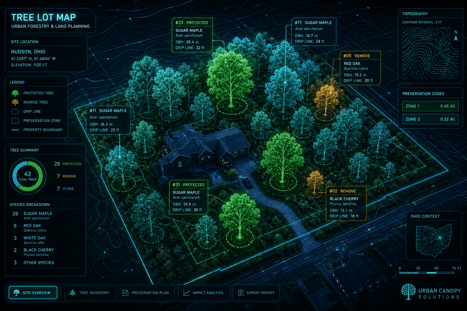
High-fidelity lot maps change the game
Old tree plans were hand-drawn circles on paper. Today you can build a digital twin of the lot:
- GPS-tagged tree locations
- dbh and species in a database
- Drip lines and protection zones drawn automatically
- Grade changes overlaid on topography
- Before/after views for city review
That is what the cyberpunk-style map in this article represents — not fantasy, but the direction site planning is heading: a live 3D tree map you can click, measure, and update.
For Mill Hollow and similar Foundation parcels, that kind of map makes it easier to:
- Show the Forester exactly which maples stay
- Prove protective barriers match drip lines
- Tie tree decisions to grading and drainage permits in one view
What happens if trees are removed without a permit
Chapter 1025 is serious:
- Fines per violation per day
- Civil penalties based on tree value formulas from the International Society of Arboriculture
- The city can withhold building permits or certificates of occupancy until issues are fixed
Replacement trees
If trees come out, Strongsville often requires replacements on a schedule by zoning district — for example, residential lots may need 2 trees totaling 6 inches dbh, or more per acre on larger developments. The Forester picks placement to reduce environmental impact.
Bottom line
A Tree Preservation Plan is a tree map + protection plan the city uses to decide if your grading, drainage, and building work can proceed.
You do not need to love the paperwork. You do need to understand it: measure the trees, show the plan, protect what stays, replace what must go.
That is the whole game.