Stand at the front of the property near Mill Hollow Lane and look down the line. What you see now is a tree lawn, a slope, and water that has always moved through this land whether anyone shaped it or not. What the Foundation is asking permission to build is something different: a channel — four feet deep, the width of a single mini-excavator scoop, running the full length of the lot from the front tree lawn all the way back to the storm drain near the twenty-five-foot drainage easement.
No cement. No hardscape. Just earth shaped carefully, water given a clear path, and grading corrected in the back where the lot has sat on natural grade too long without a proper survey.
On June 13, 2026, the Wesley Stump Family Foundation filed Building Permit #26001679 with the City of Strongsville Building Department to make that channel real.
This is not a small paperwork step. It sits at the intersection of three Foundation missions — Ground, Learn, and the quiet work of stewardship that ties them together.
Ground: Water First
The Foundation's restoration work at Mill Hollow has always started with water. The yellow lilies proved the pond was alive. The culvert proved the upland was feeding it. What was missing was the connective tissue — a channel that links the front of the lot to the back, moves water the way the land's topography intends, and gives the wetland a cleaner, more predictable flow.
This is private land. It is not a public park, not a municipal waterway, and not open access. It is a working restoration parcel where the Foundation shapes drainage, protects root systems, and stewards what grows at the low point — including the yellow lilies that made the creek and wetland project the top priority for Summer 2026.
The permit asks Strongsville to recognize a deliberate correction: earth moved with purpose, water given a defined corridor, and the rear grade brought into alignment with the drainage easement that already exists on paper.
Learn: The Technology of a Canal
The Learn program explores tools, languages, systems, and ways of thinking — including technologies that outlast their inventors. The Ohio and Erie Canal was one of those systems.
Before railroads dominated the Midwest, canals were the infrastructure. A narrow cut through the earth. A towpath. A horse. A boat. Water held at a controlled depth, moving goods and people through valleys and forests that are still here today. That is engineering — not digital, but no less precise. Grade, flow, lock, and line.
The Mill Hollow channel is not a replica of the Ohio and Erie Canal. It is a private drainage feature inspired by that history — a way to study, on a small scale, how people once moved water through the same kind of wooded Ohio landscape the Foundation is restoring now.
The Foundation is developing educational material around this project: how canal technology reshaped Northeast Ohio's valleys, how forested watersheds fed those waterways, and how private land today can still carry that story forward without becoming public infrastructure. That content will live under Learn — history told through soil, slope, and the systems that connect them.
The View From the Front
The vision starts at the street.
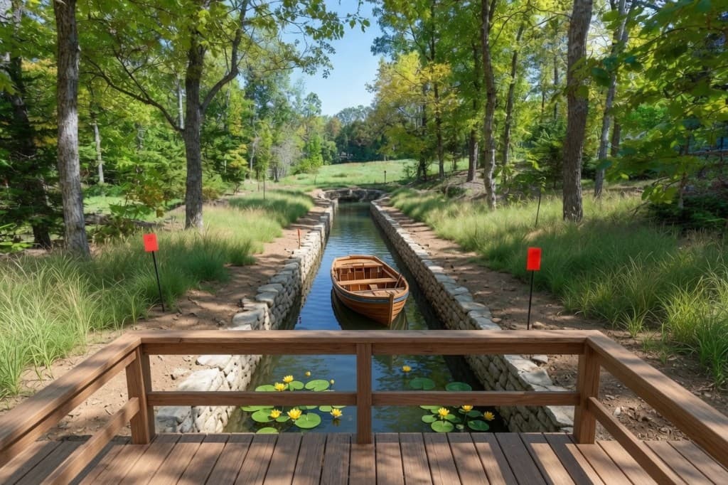
From the front tree lawn, the channel reads like something out of Ohio's canal past — a narrow ribbon of still water cutting through the property. Not a pool. Not a pond dug for show. A working waterway that carries rainfall and runoff from the upper lot down to where the land already wants to drain.
At the front edge, the Foundation plans a viewing deck with a guardrail — timber construction, consistent with other low-impact structures across Foundation properties. Stand there and look down: the channel below, yellow lilies at the far end in summer, a wooden boat resting on quiet water the way canal boats once rested in lock pools along the Erie line.
Picture standing on that deck at dusk. The guardrail at your waist. Water dark and still beneath you. Lilies spread across the low point. Red surveyor stakes marking the boundaries along the banks — the same stakes the permit requires be reset before any earth moves.
It is private. It could, over time, support public educational content about the history of Ohio's valleys and forests — written, photographed, and recorded from this vantage point. But the land itself stays under Foundation stewardship.
That is what this permit is for.
What Comes Next
Permit #26001679 is now in the City of Strongsville's review queue. Before any earth moves, the Foundation will:
- Complete the surveyor stake reset so every cut and fill stays within the legal boundaries of the lot
- Coordinate with Strongsville Building & Housing on grading and drainage requirements for the residential zone
- Finalize the front deck and guardrail design
- Sequence excavation so the mini-excavator work disturbs the smallest possible root zone along the channel route
- Expand the Learn section with canal history content tied to this project
Construction is not expected to begin until permit approval and survey work are complete. The Foundation will document the grading process and the channel's effect on downstream flow to the lily pond throughout the 2026 season.
"Canals were how this region learned to move," said a Foundation representative. "We're not building a public canal. We're building a private channel that teaches the same lesson — water has to go somewhere, and if you shape the path with care, the land answers. The deck at the front is where you stand to see that answer. The lilies are how you know it's working."
The lilies will keep blooming while the paperwork moves. When the channel is cut and the deck is built, they will be the view from the guardrail — yellow on dark water, proof that Ground and Learn share the same source.
That is the step being taken today.